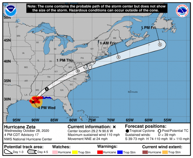
Zeta comes ashore near Cocodrie as Category 2 storm
Editor's Note: The National Hurricane Center and The Associated Press reported that Hurricane Zeta came ashore in southeastern Louisiana 3:45 p.m.-4 p.m. The AP says the center of the storm landed near Cocodrie. In the half-hour before landfall, sustained winds were measured at 110 mph.
While St. Mary and Lower St. Martin parishes still are under a tropical storm watch, a storm surge warning has been downgraded to a coastal flood advisory in St. Mary Parish as Zeta heads towards the southeast Louisiana coast.
Although Zeta’s track has remained the same, it has reemerged as a hurricane during the night and has intensified to 90 mph. It is expected to be a Category 2 storm upon landfall in southeast Louisiana late Wednesday afternoon.
The change from a storm surge warning to a coastal flood advisory was made because Zeta’s track should remain far enough east of the area to alleviate any major storm surge, while the cold front headed for southwest Louisiana also played a role, too, said Andy Patrick, meteorologist-in-charge at the National Weather Service’s Lake Charles office.
However, the weather service does expect tides reaching 1-2 feet above ground level.
The coastal flood advisory is effective until 7 p.m. Wednesday.
With the updated predictions, the St. Mary Parish Levee District will monitor conditions but not order gates at the Franklin, Hanson or Yellow Bayou canals closed.
“Most of those gates can be closed last minute, if necessary,” Levee District Operations Manager Mike Brocato said at the 4 p.m. Tuesday briefing. “Otherwise, it’s better just to let the rainfall leave by gravity instead of having to pump it.”
While public and parochial schools have cancelled classes Wednesday, no evacuations were deemed necessary by St. Mary Parish President David Hanagriff.
With Zeta approaching Louisiana, a tropical storm watch is in effect from Intracoastal City to Morgan City.
St. Mary Parish could receive northeast winds ranging from 30-40 mph with gusts reaching 50 mph. These can begin anywhere from 9 a.m. to noon and end from 5 p.m. to 8 p.m., the National Weather Service said.
“The highest wind gusts are expected over southeast St. Mary Parish,” Patrick said in a Wednesday morning update. “Winds over these areas should diminish quickly this evening.”
In Lower St. Martin Parish, northeast winds from 25 mph to 35 mph with gusts reaching 45 mph are expected. These are expected to begin around 10 a.m. to noon and end between 4 p.m. and 7 p.m.
“That doesn’t mean it’s going to happen all the time, and in fact, it’s probably likely it’s just going to be a brief duration, but these are going to be the potential wind speeds we think that could occur once Zeta begins to move closer to land,” Patrick said.
Locally, the National Weather Service has downgraded the amount of rain expected in St. Mary and Lower St. Martin parishes from 2-4 inches to 1-2 inches.
