UPDATED: Afternoon storm update; forecasters use the 'h' word
National Hurricane Center
12:30 p.m. update
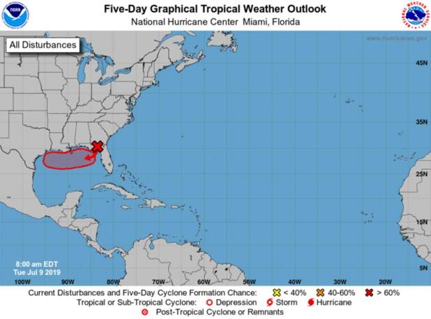
The National Hurricane Center has a high 80 percent chance for tropical development in the northern Gulf of Mexico. The current scenario shows a potential tropical cyclone developing on Wednesday or Thursday in the northeastern Gulf of Mexico, heading west towards the upper Texas or southwest Louisiana region. This system has the potential to become a dangerous hurricane. The threat for damaging winds and deadly storm surge is increasing.
Since this system has not developed yet, there is still considerable uncertainty to the exact timing, magnitude, and location of these threats. Everyone should continue to monitor the weather this week.
Morning update
For the North Atlantic...Caribbean Sea and the Gulf of Mexico:
1. A broad low pressure system located over the eastern Florida
Panhandle is producing disorganized shower activity. The low is
forecast to move southward to southwestward and emerge over the
northeastern Gulf of Mexico later today. Once the system is over
water, environmental conditions are expected to be conducive for
tropical cyclone formation, and a tropical depression is likely to
develop by late Wednesday or Thursday while the system moves
westward across the northern Gulf of Mexico. Regardless of whether
or not a tropical cyclone forms, this system has the potential to
produce heavy rainfall along portions of the northern and eastern
U.S. Gulf Coast later this week. For more information about the
rainfall threat, please see products issued by your local weather
forecast office and the NOAA Weather Prediction Center. Interests
along the Gulf Coast from the Upper Texas coast to the western
Florida peninsula should monitor the progress of this system.
* Formation chance through 48 hours...medium...50 percent.
* Formation chance through 5 days...high...80 percent.
From Tuesday's print edition
Staff and Wire Reports
St. Mary Parish is getting both summer heat and a chance of more spring-like heavy rain this week.
A heat advisory is in effect until 7 p.m. Tuesday, while a weather system is making its way into the Gulf, bringing with it the prospect of heavy rain.
The mercury is expected to reach 93 degrees Tuesday afternoon. The heat index, the combined effects of temperature and humidity, is expected to reach 108-110 degrees, according to the National Weather Service.
Tuesday is the second straight day a heat advisory has been in effect.
Harry P. Williams Memorial Airport near Patterson recorded a temperature of 93 degrees just before 3 p.m. Monday.
The advisory says people should drink plenty of fluids, stay in an air-conditioned room, stay out of the sun and check on relatives and neighbors.
Take extra precautions if you work or spend time outside, the advisory says. When possible, reschedule strenuous activities to early morning or evening. Know the signs and symptoms of heat exhaustion and heat stroke. Wear lightweight and loose fitting clothing when possible and drink plenty of water.
Meanwhile, the Hurricane Center says a tropical depression is likely to form in the Gulf of Mexico by the end of the week.
Forecasters in Miami said Monday that a trough of low pressure over central Georgia is forecast to move southward toward the northeastern Gulf where a broad area of low pressure will form in a couple of days.
The forecasters say the system has the potential to bring heavy rain along the northern and eastern U.S. Gulf.
To help its residents prepare for the rain, the city of Tallahassee has opened four sandbag distribution centers.
Florida Gov. Ron DeSantis on Monday urged Floridians to be prepared.
He says residents in north and central Florida should be ready for heavy rain and the potential for flooding in low-lying areas.
High water has been a fact of life for this region since Mardi Gras, when backwater flooding along Bayou Chene began to threaten homes in Stephensville.
The St. Mary Parish Levee District installed a flood control barge in Bayou Chene for the third time since 2011.
State officials announced in March that funding has been secured for a permanent flood-control structure that will do the work that has been performed by the barge.
The Atchafalaya River at Morgan City was at 7.6 feet Monday night, the National Weather Service said. Flood stage is 6.0 feet.
And one-day downpours in April and June caused headaches for homeowners in the region.
After one of the downpours June 7, 39 Berwick residents reported water in their homes.
Officials in Patterson and Berwick have announced plans to examine flood-control and drainage measures.
