
UPDATED 10 P.M.: Marco remains tough to predict
FROM THE NATIONAL HURRICANE CENTER
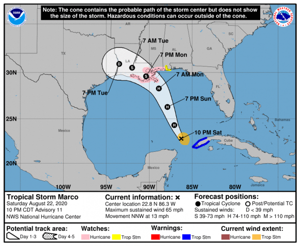
TROPICAL STORM MARCO
NWS National Hurricane Center Miami FL AL142020
1000 PM CDT Sat Aug 22 2020
Marco has taken on distinctly sheared appearance. Reports from an
Air Force Reserve Hurricane Hunter plane, microwave imagery, and
radar imagery from Cuba all indicate that deep convection is limited
to the east side of the tropical storm and that it no longer has a
nearly closed eyewall. The degradation of Marco's structure appears
to be primarily due to strong upper-level southwesterly flow.
Despite the shear, the plane still measured SFMR winds near 55 kt
and the intensity is held at that value.
Marco is a small tropical storm and will be susceptible to rapid
changes in structure and intensity until it reaches the northern
Gulf Coast. Such systems are often not very resilient in a
high-shear environment, however even a brief relaxation of the shear
could result in quick strengthening. It would not be surprising if
Marco's intensity evolves in step-wise fashion consisting of periods
of arrested development followed by fast strengthening if/when the
shear relaxes. While the statistical models still show Marco
becoming a hurricane within 24 h, the run-to-run consistency of the
dynamical guidance remains poor. The latest HWRF, HMON and GFS
forecasts show Marco weakening as it approaches the northern Gulf
Coast, and this remains a distinct possibility if the shear remains
consistently high. The NHC intensity forecast has not been changed
substantially, in large part due to the low confidence of the
forecast, and is consequently above all of the guidance at 36 and 48
h when Marco is forecast to be near the northern Gulf Coast.
Additional adjustments to the forecast are likely on Sunday.
In sharp contrast to earlier today, no large changes were made to
the track forecast, though that should not be interpreted as an
increase in forecast confidence. Marco is forecast to move
north-northwestward and approach the northern Gulf Coast on Monday.
As it moves inland and weakens, a turn toward the west at a slower
forward speed is anticipated. This turn could occur before or after
Marco moves inland, and will be tied in part to exactly when Marco
begins to weaken since a stronger, deeper storm should continue to
feel the affects of the upper-level southwesterly flow and move
farther north while a weaker system will be steered westward by a
low- to mid-level ridge extending over the southeastern US. The NHC
forecast is nearly on top of the multi-model consensus, but the
spread in the guidance is still higher than normal.
Key Messages:
1. Tropical storm conditions will continue over portions of extreme
western Cuba for a few more hours. Heavy rainfall is also expected
overnight in the eastern portions of the Mexican states of Quintana
Roo and Yucatan, and across far western Cuba, which could result in
flash flooding.
2. Marco is expected to be at or near hurricane strength when it
approaches the central Gulf Coast as a hurricane on Monday.
Hurricane conditions, life-threatening storm surge, and heavy
rainfall are possible along portions of the Gulf Coast beginning on
Monday, and Hurricane and Storm Surge watches have been issued.
Interests in these areas should follow any advice given by local
government officials.
3. Tropical Storm Laura could bring additional storm surge,
rainfall, and wind impacts to portions of the U.S. Gulf Coast by the
middle of next week. This could result in a prolonged period of
hazardous weather for areas that may also be affected by Marco.
Interests there should monitor the progress of Marco and Laura and
updates to the forecast during the next few days.
FORECAST POSITIONS AND MAX WINDS
INIT 23/0300Z 22.8N 86.3W 55 KT 65 MPH
12H 23/1200Z 24.3N 87.1W 65 KT 75 MPH
24H 24/0000Z 26.3N 87.9W 70 KT 80 MPH
36H 24/1200Z 28.3N 88.9W 70 KT 80 MPH
48H 25/0000Z 29.6N 90.4W 55 KT 65 MPH...INLAND
60H 25/1200Z 30.5N 92.0W 35 KT 40 MPH...INLAND
72H 26/0000Z 30.9N 93.5W 30 KT 35 MPH...INLAND
96H 27/0000Z...DISSIPATED
$$
Forecaster Zelinsky
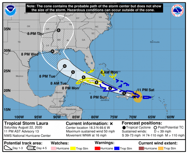
TROPICAL STORM LAURA
NWS National Hurricane Center Miami FL AL132020
1100 PM AST Sat Aug 22 2020
Laura is now located near the eastern portion of the Dominican
Republic, and it is producing a large area of showers and
thunderstorms over much of Hispaniola and adjacent areas. The NOAA
Hurricane Hunters have been flying in the tropical storm this
evening and have found winds to support maintaining the initial
intensity of 45 kt. Dropsonde data from the aircraft suggests that
the pressure has fallen a little to 1003 mb, and that the center is
still quite elongated.
Laura is moving west-northwestward at 14 kt. The track forecast
reasoning is generally unchanged from earlier. A subtropical high
pressure system is expected to build westward during the next few
days, which should continue to steer Laura generally
west-northwestward at a fairly quick pace. This track should take
the storm across Hispaniola tonight and early Sunday and then across
Cuba late Sunday and Monday. Laura is then expected to emerge over
the eastern Gulf of Mexico, where it will likely turn northwestward
and slow down some as it reaches the western side of the ridge. The
models are in fair agreement that Laura will generally follow a
similar path to Marco when it nears the northern Gulf coast in 3 to
4 days. There has been little change in the guidance this cycle,
and the NHC track forecast is largely an update of the previous one.
This forecast is near the typically reliable TVCA and HCCA
consensus aids.
Since the tropical storm is expected to track across the
mountainous islands of Hispaniola and Cuba during the next 36
to 48 hours, little change in intensity seems like a good bet during
that time period. However, after the storm pulls away from the
islands and moves over the warm Gulf of Mexico waters while being
in low wind shear and high moisture conditions, strengthening seems
very likely. Most of the better-performing intensity models show
Laura making landfall along the U.S. northern Gulf coast as a
hurricane in about 4 days. The NHC intensity forecast is slightly
higher than the previous one, and it lies roughly near the middle
of the guidance suite.
Key Messages:
1. Tropical storm conditions are expected to continue across
portions of the U.S. Virgin Islands and Puerto Rico for a few more
hours. Tropical storm conditions are also expected across portions
of the Dominican Republic and Haiti, the Turks and Caicos, the
southeastern Bahamas, and central and eastern Cuba through Sunday.
Heavy rainfall is likely across these areas and could cause
mudslides and flash and urban flooding through Sunday, with
widespread river flooding possible in Puerto Rico.
2. Tropical storm conditions are possible over portions of
central and western Cuba, the central Bahamas and Andros Island
Sunday night and Monday, and in the Florida Keys on Monday.
3. The details of the long-range track and intensity forecasts
remain uncertain since Laura is forecast to move near or over
portions of the Greater Antilles through Monday. However, Laura is
forecast to strengthen over the Gulf of Mexico and could bring storm
surge, rainfall, and wind impacts to portions of the U.S. Gulf Coast
by the middle of next week. This could result in a prolonged period
of hazardous weather for areas that are likely to be affected by
Tropical Storm Marco earlier in the week. Interests there should
monitor the progress of Laura and Marco and updates to the forecast
during the next few days.
FORECAST POSITIONS AND MAX WINDS
INIT 23/0300Z 18.3N 69.6W 45 KT 50 MPH
12H 23/1200Z 19.3N 72.3W 45 KT 50 MPH...INLAND
24H 24/0000Z 20.6N 76.0W 45 KT 50 MPH...INLAND
36H 24/1200Z 22.1N 79.6W 45 KT 50 MPH...INLAND
48H 25/0000Z 23.4N 83.0W 50 KT 60 MPH...OVER WATER
60H 25/1200Z 24.7N 85.8W 60 KT 70 MPH
72H 26/0000Z 26.2N 88.0W 75 KT 85 MPH
96H 27/0000Z 29.8N 91.2W 80 KT 90 MPH...INLAND
120H 28/0000Z 34.7N 89.6W 30 KT 35 MPH...INLAND
$$
Forecaster Cangialosi
