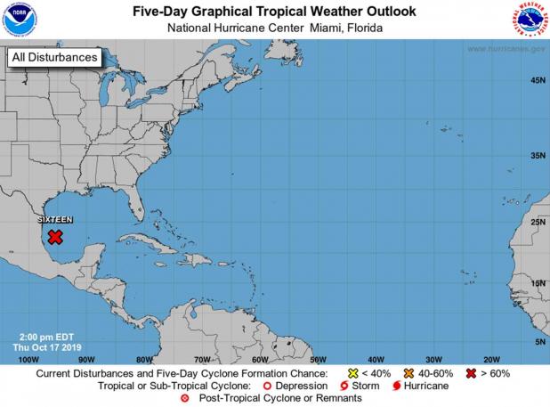
Update on tropical weather system in Gulf
The National Hurricane Center has issued this statement about the tropical system in the Gulf. The National Weather Service says the only impacts in St. Mary Parish may be higher than normal tides.
...DISTURBANCE OVER THE SOUTHWESTERN GULF OF MEXICO EXPECTED TO
DEVELOP INTO A TROPICAL OR SUBTROPICAL STORM LATER TODAY OR
TONIGHT...
...TROPICAL STORM WARNINGS ISSUED FOR PORTIONS OF THE NORTHERN GULF
COAST...
SUMMARY OF 1000 AM CDT...1500 UTC...INFORMATION
-----------------------------------------------
LOCATION...22.4N 95.7W
ABOUT 140 MI...225 KM E OF TAMPICO MEXICO
ABOUT 620 MI...995 KM SW OF THE MOUTH OF THE MISSISSIPPI RIVER
MAXIMUM SUSTAINED WINDS...35 MPH...55 KM/H
PRESENT MOVEMENT...N OR 355 DEGREES AT 8 MPH...13 KM/H
MINIMUM CENTRAL PRESSURE...1007 MB...29.74 INCHES
WATCHES AND WARNINGS
--------------------
CHANGES WITH THIS ADVISORY:
A Tropical Storm Warning is in effect from the Mississippi/Alabama
border to the Ochlockonee River, Florida.
A Tropical Storm Warning is in effect from Grand Isle, Louisiana to
the Mouth of the Pearl River.
A Tropical Storm Watch is in effect east of the Ochlockonee River to
Yankeetown, Florida.
A Storm Surge Watch is in effect from Indian Pass, Florida, to
Clearwater, Florida.
000
WTNT41 KNHC 171503
TCDAT1
Potential Tropical Cyclone Sixteen Discussion Number 1
NWS National Hurricane Center Miami FL AL162019
1000 AM CDT Thu Oct 17 2019
A complicated weather situation is evolving in the Gulf of Mexico.
The circulation associated with the tropical disturbance over the
southwestern Gulf of Mexico is getting better defined, and the
associated convection is getting better organized. However, a
strong mid- to upper-level trough is moving eastward across
southern Texas and northern Mexico, and a frontal system is present
over the northern and northwestern Gulf of Mexico. The ECMWF and
GFS models suggest that the trough will spawn a low along the
front, with the tropical disturbance merging with that low. On the
other hand, the UKMET suggests the tropical disturbance will become
the primary low pressure system. Either way, it is likely that a
low pressure area with gale-force winds and at least some tropical
cyclone characteristics will move northeastward and affect
portions of the northern Gulf coast during the next 36-48 h. Based
on this, advisories are initiated on Potential Tropical cyclone
Sixteen, and coastal tropical cyclone and storm surge
watches/warnings are being issued.
The system should track generally northeastward in the southern
portion of the mid-latitude westerlies, and the track model
guidance is in reasonably good agreement through 96 h. The forecast
track lies a little to the south of the model consensus, as the
UKMET has a somewhat more southerly track. The forecast track
brings the system across the southeastern United States between
48-72 h, and then has it moving into the Atlantic east of the
mid-Atlantic States.
Gradual strengthening is expected as strong upper-level
divergence caused by the trough partly prevails over strong
vertical shear. Thus, the intensity forecast calls for gradual
strengthening along the lines of that in the global models. It is
unlikely, though, that the system will develop into a classical
tropical cyclone. The system is expected to be fully extratropical
by 48 h, with gradual weakening expected after that time.
Regardless of the exact evolution of this weather system, portions
of the northern coast of the Gulf of Mexico will experience strong
winds, locally heavy rains, and storm surge Friday and Saturday.
Similar impacts are expected across portions of the Atlantic coast
of the southeastern United States Saturday and Sunday.
FORECAST POSITIONS AND MAX WINDS
INIT 17/1500Z 22.4N 95.7W 30 KT 35 MPH...POTENTIAL TROP CYCLONE
12H 18/0000Z 23.7N 94.2W 35 KT 40 MPH...TROPICAL STORM
24H 18/1200Z 25.8N 91.0W 40 KT 45 MPH
36H 19/0000Z 28.5N 88.0W 45 KT 50 MPH
48H 19/1200Z 30.9N 85.0W 45 KT 50 MPH...POST-TROP/EXTRATROP
72H 20/1200Z 35.5N 77.2W 35 KT 40 MPH...POST-TROP/EXTRATROP
96H 21/1200Z 37.5N 70.0W 30 KT 35 MPH...POST-TROP/EXTRATROP
120H 22/1200Z 38.0N 66.5W 25 KT 30 MPH...POST-TROP/EXTRATROP
