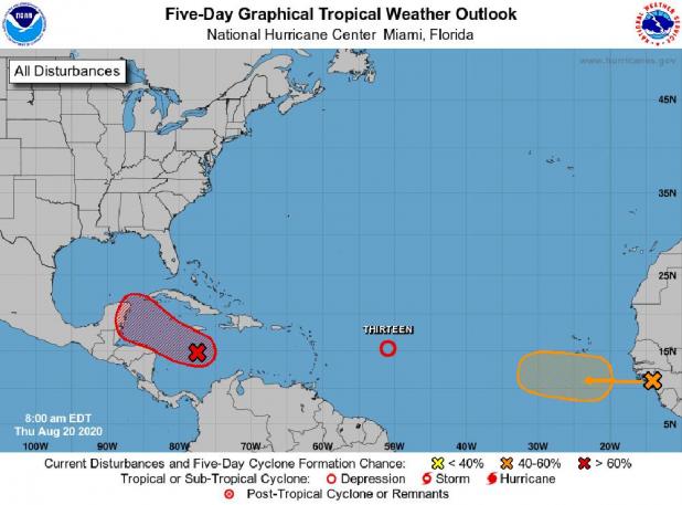
TD 13 expected to become tropical storm Thursday
According to the National Weather Service Hurricane Center in Miami, Tropical Depression 13 is moving west-northwest at 21 mph with little change of strength as of the 5 a.m. advisory.
It was located at 15.2N, 49.8W about 905 miles east of the northern Leeward Islands with maximum sustained winds of 35 mph. On the forecast track, the depression is expected to move near or north of the northern Leeward Islands by late Friday and near or north of the Virgin Islands and Puerto Rico on Saturday.
Gradual strengthening is forecast, and the depression is expected to become a tropical storm Thursday.
The National Hurricane Center forecast shows Tropical Depression 13 approaching Florida and the Gulf of Mexico as a strong tropical storm by early next week. But there are many factors hindering the storm including the possibility it could move over the Greater Antilles this weekend.
In the center Caribbean Sea, showers and thunderstorms continue to become better organized and became Tropical Depression 14 as the system approaches the northwestern Caribbean Sea.
This disturbance will likely produce heavy rains across a large portion of Central America and southeastern Mexico late this week and this weekend. Formation chance through 48 hours to five days is 90%.
A tropical wave over western Africa is producing disorganized showers and thunderstorms. This wave is expected to move over the far eastern tropical Atlantic on Friday, and some slow development is possible through the weekend while it moves west-northwestward at 15 to 20 mph across the eastern tropical Atlantic.
Formation chance through 48 hours is 10% and through five days is 40%.
