Officials: Gordon should have minimal impact on St. Mary
St. Mary Parish leaders prepared for the worst, but Tropical Storm Gordon appeared Tuesday morning that it will have minimal if any impact on the parish, according to officials.
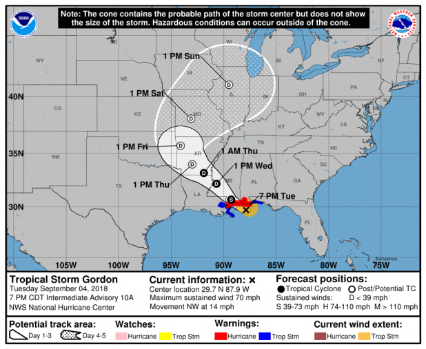
As of Tuesday morning, the National Weather Service projected Gordon to make landfall Tuesday night on the Mississippi coast. The storm’s winds were at 65 mph as of 7 a.m., but forecasters anticipated the storm becoming a hurricane before making landfall.
“It was kind of a good practice run for us,” said David Naquin, director of the St. Mary Parish Office of Homeland Security and Emergency Preparedness. “We had to gear up as though it was going to hit us.”
“As the track went further east, and it’s still moving east, that just draws it that much further away from us. I think our impacts are going to be relatively low, if any at all,” he said.
National Weather Service and National Hurricane Center officials have indicated to area leaders that they’re “very confident” where the storm is headed, and the impact to St. Mary Parish should be “hardly anything,” he said.
“The storm could actually still take a turn. But, again, the confidence level (for the projected path) is very high for both the weather service and the hurricane center,” Naquin said.
Parish officials have designated sand bag filling locations just as a precaution. People should bring their own shovels for all sandbag filling spots.
St. Mary Parish government had sand and sandbags available beginning Tuesday morning in Amelia under the La. 182 bridge and in Bayou Vista at the public works barn.
Also on Tuesday, the city of Patterson Public Works Department was scheduled to have sand and bags available across the tracks at the fire station and outside the gate on Taft Street.
St. Mary Parish School Board administrators watched the storm overnight but decided to open schools Tuesday.
The Patterson City Council, scheduled to meet Tuesday, postponed its meeting until 6:30 p.m. Sept. 11.
Officials don’t expect to have to operate the Walnut Canal barge in Morgan City as the water level shouldn’t reach the threshold for operation, said Lee Dragna, board chairman for St. Mary Parish Consolidated Gravity Drainage District No. 2. Pumping stations in the Morgan City area are ready for use should they be necessary, Dragna said.
Naquin reminded area residents that now is the time “to go over your game plan” if a storm hits the area and they had to evacuate. He encouraged people to practice their plan.
On the west end of the parish, sand bags are available at the Hanson public works barn and District 11 fire station in Four Corners.
Meanwhile, Tropical Storm Gordon lashed South Florida with heavy rains and high winds on Monday and is expected to strengthen into a hurricane when it hits the central U.S. Gulf Coast.
Gordon formed into a tropical storm near the Florida Keys early Monday as it moved west-northwest at 17 mph. The storm is expected to reach hurricane strength when it hits the Gulf Coast, including coastal Mississippi, by late Tuesday. From there, it is forecast to move inland over the lower Mississippi Valley on Wednesday.
A hurricane warning was put into effect for the area stretching from the mouth of the Pearl River in Mississippi to the Alabama-Florida border. As much as 8 inches of rain could fall in some parts of the Gulf states through late Thursday.
The Miami-based center said the storm is also expected to bring “life-threatening” storm surge to portions of the central Gulf Coast. A storm surge warning has been issued for the area stretching from Shell Beach, Louisiana, to Dauphin Island, Alabama. The warning means there is danger of life-threatening inundation. The region could see rising waters of 3 to 5 feet.
“The deepest water will occur along the immediate coast near and to the east of the landfall location, where the surge will be accompanied by large waves,” the center said.
Louisiana Gov. John Bel Edwards declared a state of emergency Monday and said 200 National Guard troops will be deployed to southeastern Louisiana.
The storm’s predicted track had shifted slightly east as of Monday evening, meaning Louisiana is currently just outside the area under the hurricane warning. Still, the southeastern part of the state remains under a tropical storm warning and residents need to be prepared for the storm to shift west, Edwards said.
“This storm has every possibility to track further in our direction,” Edwards said during a news conference Monday evening.
New Orleans Mayor LaToya Cantrell held an afternoon news conference and said the city has “the pumps and the power” needed to protect residents. But authorities issued a voluntary evacuation order for areas outside the city’s levee protection system, including the Venetian Isles, Lake Saint Catherine and Irish Bayou areas.
Cantrell urged residents within the levee protection area to stock up on supplies and shelter in place.
This story has been changed to correct the Patterson City Council's Sept. 11 meeting time.
