NOAA agrees: Hurricane season will be busy
The second of two closely watched hurricane predictions generally agrees with the first: the 2021 Atlantic-Gulf of Mexico season is likely to be an active one.
In St. Mary, a new $11 million flood control structure designed to block storm surge worked as it should Friday, when officials responded to the potential effects of a system in the Gulf, said Levee District Executive Director Tim Matte.
“The predictions are for an active season,” Matte said. “I’m afraid we’ll get to use it again before too much longer.”
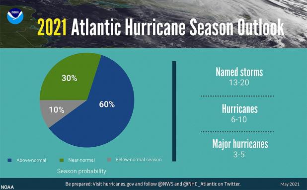
The National Oceanic and Atmospheric Administration’s Climate Prediction Center said late last week that it calculates a 60% chance for another more-active-than-normal Atlantic hurricane season, a 30% chance for a near-normal season and a 10% chance for a quieter-than-normal season.
“However,” NOAA said in a press release, “experts do not anticipate the historic level of storm activity seen in 2020.”
Eight named storms made their way to Louisiana last year, including Laura. That storm’s 145 mph wind in extreme southwest Louisiana was the strongest to strike the state in 150 years.
Speaking Wednesday at a St. Mary Chamber luncheon in Morgan City, state Insurance Commissioner Jim Donelon said 82% of wind damage claims have been closed in that area, which was also hit by Hurricane Delta.
But Donelon expects many secondary claims because of spikes in the price of lumber and labor.
This year’s NOAA prediction translates into 13 to 20 named storms (winds of 39 mph or higher), of which six to 10 could become hurricanes (winds of 74 mph or higher), including three to five major hurricanes (category 3, 4 or 5, with winds of 111 mph or higher).
NOAA recalculated its average storm totals this year: 14 named storms, seven hurricanes and three major hurricanes.
The other most-watched hurricane forecast, from Colorado State University, is for 17 named storms in 2021, eight hurricanes and four major hurricanes.
One of the key factors in hurricane predictions is the status of the El Niño Southern Oscillation, a pattern of varying water temperatures in the southern Pacific Ocean.
El Niño patterns, when the water is warmer, tend to reduce hurricane development with shearing wind. The cooler La Niña patterns are more favorable to hurricane development.
The current status is neutral, although we’ve just emerged from a La Niña pattern, and La Niña could return by the end of the hurricane season, NOAA said.
“ENSO-neutral and La Niña support the conditions associated with the ongoing high-activity era,” said Matthew Rosencrans, lead seasonal hurricane forecaster at NOAA’s Climate Prediction Center. “Predicted warmer-than-average sea surface temperatures in the tropical Atlantic Ocean and Caribbean Sea, weaker tropical Atlantic trade winds, and an enhanced west African monsoon will likely be factors in this year’s overall activity.”
The hurricane season officially begins June 1, but the first named storm of the season has already come and gone. That was Tropical Storm Ana, which spun itself out in the Atlantic over the weekend.
At the same time, St. Mary officials were being warned about a storm system off the Texas coast that could have brought more rain on top of last week’s downpour as well as tides 2 to 3 feet higher than normal.
That led to the closing of the Franklin flood gate, gates in the Morgan City and Berwick flood walls, and the new Bayou Teche Flood Control Structure.
The Teche structure is designed to block storm surge from moving through the Charenton Canal into the Bayou Teche. The $11 million project consists of a permanent gate into which a barge can be swung in place.
This year actually marks the second time the structure has been used to block potential flooding. In 2020, as Hurricane Delta approached, the barge was not yet ready to be moved into the gate. So the Levee District put sheet piles in place across the gate’s opening.
On Friday, the barge was ready for action, but the decision to close the new Teche gate presented the Levee District with a dilemma, Matte said.
“We delayed closing it as long as possible because the Teche was still draining,” Matte said.
That means the bayou was still moving the runoff from last week’s heavy rain. The gate wasn’t closed until after 6 p.m. Friday.
In the end, the system added no noticeable rainfall to last week’s storms and little additional tide.
At mid-afternoon Friday, the Atchafalaya River at Morgan City was at 5.7 feet, or 0.3 feet below the stage at which minor flooding occurs between the Morgan City and Berwick flood walls. The stage was down to 5.4 feet at mid-afternoon Monday.
Even without the added tropical disturbance and without the 15-inch one-day rains that fell on Lake Charles and Baton Rouge last week, residents of this region got all the water they wanted and more.
Isolated street flooding occurred across the region.
In lower St. Martin, the parish government declared an emergency, restricted access to some homes, enacted a no-wake zone and made sandbags available.
On Saturday, Assumption Parish Detention Facility inmates prepared over 14,000 sand bags and all were distributed to property owners, Sheriff Leland Falcon said.
On Friday, Falcon purchased another sandbagging machine in order to meet the needs for the current flood disaster. The sheriff purchased the first sandbagger a year ago.
