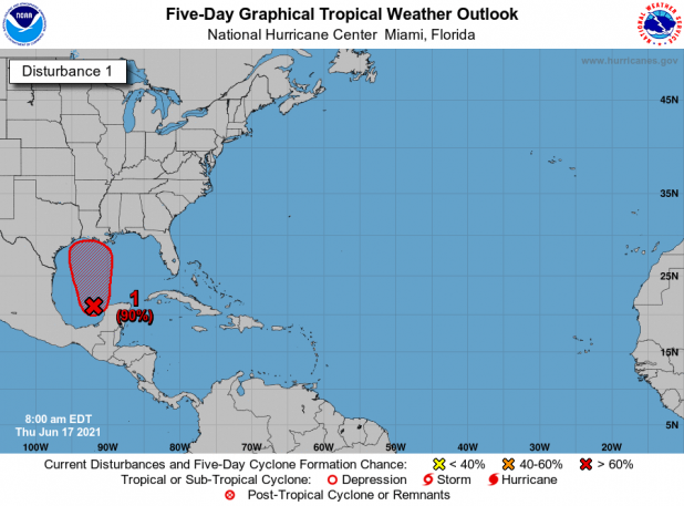
NHC says 90% chance of tropical development
The National Hurricane Center has upgraded the chance to 90% of the disturbance in the southern Gulf of Mexico experiencing tropical development in the next five days, while there is a 70% chance in the next two days, the National Weather Service’s Lake Charles office reported during a Facebook Live weather briefing Wednesday afternoon.
The system, National Weather Service meteorologist Donald Jones said, likely is expected to begin to move northward at a maximum speed of 10 mph, beginning Thursday.
“So it’s going to take a couple days for it to lift across the Gulf Coast,” he said.
It could become a tropical depression Thursday or Friday and potentially later develop into a tropical storm, Jones said.
“Relatively weak” was how he described the disturbance’s impacts.
“We’re not talking about a major hurricane at this point,” Jones said. “This is mainly going to be a heavy rainmaker. It will be gusty out there, but we’re not looking at anything on the order of (Hurricane) Laura or anything like that.”
Locally, those impacts will be felt here Saturday and Sunday, but could begin early Friday from outer bands bringing scattered showers.
While Wednesday afternoon’s forecast predicted rainfall totals of 3-4 inches in the Morgan City area, those are lower than what were anticipated Tuesday. The area also is predicted to experience wind gusts reaching 26 mph.
“Based on the current tracks and kind of where we expect it to go, it looks like those higher wind gusts are going to be south central Louisiana, so say New Iberia, Morgan City, over into the parts of southeast Louisiana maybe towards Houma, Thibodaux, right along the coastline,” Jones said.
Tides also are expected to be above average by a foot or two, which could mean flooding in coastal areas, including St. Mary Parish.
Many of the National Weather Service models had the storm hitting near the Texas/Louisiana line Tuesday afternoon, but that has shifted to potentially Vermilion Bay as of Wednesday afternoon. However, it’s further to the east of the storm where the heaviest rain is anticipated to be felt.
“It still kind of remains to be seen,” Jones said of the landfall. “There’s going to be some fluctuation there over the next day or two, but that’s kind of the idea behind these rainfall totals at this point.”
St. Mary Parish government announced in a Facebook post that sand and sand bags are available in the Tri-City area at the public works facility at 2717 La. 182 East in Bayou Vista and under the La. 182 bridge in Amelia.
In Patterson, the city announced on its Facebook page that sand and sand bags are being offered, beginning Thursday afternoon at the city’s Public Works Plant (water tower) on Taft Street for the city’s residents in vulnerable areas. Residents will need to bring their own shovel.
Meanwhile, St. Martin Parish Government said in a Facebook post Wednesday afternoon it has been monitoring the storm and will continue to do so. As of now, the parish government said it would open sand bagging operations Friday at 7 a.m., if necessary, but that could be moved up, if need be. The parish said it would provide the public another update Thursday after its National Weather Service briefing.
