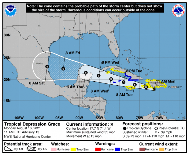
Grace's forecast track moves farther south in Gulf
Tropical Depression Grace Discussion Number 13
NWS National Hurricane Center Miami FL AL072021
1100 AM EDT Mon Aug 16 2021
Air Force Reserve and NOAA Hurricane Hunters were both able to
locate a center for Grace--probably the most well-defined center
observed over the past few days. That center now appears to be
moving onshore along the Barahona Peninsula of the Dominican
Republic as we speak. The planes measured several possible areas
of tropical-storm-force winds from the SFMR, however these
observations have not been supported by the more reliable 925-mb
flight-level winds for weaker systems, which were only as high as
38 kt, and warrant maintaining the 30-kt initial intensity.
Dropsonde data indicate that the central pressure has fallen to 1007
mb.
The aircraft fixes confirm that Grace is moving westward, or 280/13
kt. High pressure over the western Atlantic is forecast to slide
westward over the southeastern United States during the next
several days, which should keep Grace on a westward to west-
northwestward trajectory for the entire 5-day forecast period.
This scenario is agreed upon by all of the available track models,
and the new NHC track forecast has only been nudged slightly
southward from the previous forecast based on the latest consensus
aids.
Grace's intensity forecast remains complicated by interaction with
land and the possibility of some westerly shear during the forecast
period. However, the southern shift in the forecast track takes
the center of Grace more definitively over very warm 30 degrees
Celsius waters in the northwestern Caribbean Sea. Therefore,
gradual strengthening is anticipated while Grace approaches the
Yucatan coast of Mexico. Once the system reaches the Gulf of
Mexico, the shear appears to decrease, and conditions there will
likely be conducive for additional strengthening. In fact, many of
the models, including the consensus aids, bring Grace to hurricane
intensity, and the NHC intensity forecast has therefore been bumped
upward, bringing Grace very near hurricane strength by the end of
the forecast period.
Key Messages:
1. Heavy rainfall across the Dominican Republic, Haiti, Cuba,
Jamaica, and the Cayman Islands may lead to flash, urban, and small
stream flooding, with the potential for mudslides highest in Haiti
and the Dominican Republic.
2. Tropical storm conditions are possible over portions of
Hispaniola today and tonight, and over Jamaica on Tuesday.
Tropical storm conditions are expected over portions of the southern
coast of Cuba on Tuesday, spreading westward to the Cayman Islands
and other portions of the southern coast of Cuba Tuesday evening
through Wednesday morning.
3. There is a increasing risk of wind and rainfall impacts over
the Yucatan Peninsula of Mexico Wednesday night and Thursday.
Interests there areas should monitor the progress of Grace and
updates to the forecast.
FORECAST POSITIONS AND MAX WINDS
INIT 16/1500Z 17.7N 71.4W 30 KT 35 MPH
12H 17/0000Z 18.2N 73.4W 30 KT 35 MPH...S COAST OF HAITI
24H 17/1200Z 18.8N 76.2W 35 KT 40 MPH
36H 18/0000Z 19.4N 79.0W 40 KT 45 MPH
48H 18/1200Z 20.1N 82.1W 45 KT 50 MPH
60H 19/0000Z 20.9N 85.2W 50 KT 60 MPH
72H 19/1200Z 21.6N 88.4W 50 KT 60 MPH...N COAST OF YUCATAN
96H 20/1200Z 22.5N 94.0W 60 KT 70 MPH
120H 21/1200Z 23.0N 98.0W 60 KT 70 MPH...INLAND
