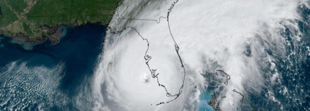
NOAA Photo
This satellite image shows Hurricane Ian approaching the Florida Gulf Coast in September.
Feds predict so-so hurricane season
As the hurricane season begins, a U.S. government forecast is for something like an average number of tropical weather events this year.
The National Oceanic and Atmospheric Administration forecast is for 12 to 17 named storms in the Atlantic Basin in 2023.
The NOAA forecast says five to nine of those storms will become hurricanes, reaching sustained winds of 74 mph. One to four of those hurricanes will be classified as
major, the prediction says, with winds of at least 111 mph.
An average year brings 14 named storms, according to NOAA, including seven hurricanes and three major hurricanes.
The officially recognized hurricane season runs June 1-Nov. 30.
Another closely watched forecast, this one from Colorado State University, predicted in April that the 2023 season will have below-average activity.
That prediction is for 13 named storms, including six hurricanes, two of them major.
Although the NOAA and Colorado State forecasts differ slightly, both point to the same underlying phenomenon: the El Niño weather pattern.
Warmer than average temperatures in the Pacific off the South American coast generate El Niño patterns, which create winds that tend to inhibit hurricane development.
The opposite is La Niña, a cold-water pattern that creates favorable conditions for tropical weather in the Atlantic, the Caribbean and Gulf of Mexico.
The catastrophic 2020 hurricane season and Hurricane Ida, which slammed the southeast Louisiana coast in 2021, all occurred during periods dominated by La Niña.
But an El Niño is no guarantee of hurricane protection. Audrey in 1957 and Andrew in 1992 occurred during periods with an active El Niño pattern.
And, the NOAA said, “El Niño’s potential influence on storm development could be offset by favorable conditions local to the tropical Atlantic Basin.
“Those conditions include the potential for an above-normal west African monsoon, which produces African easterly waves and seeds some of the stronger and longer-lived Atlantic storms, and warmer-than-normal sea surface temperatures in the tropical Atlantic Ocean and Caribbean Sea which creates more energy to fuel storm development.”
One business with a special interest in hurricanes, Cleco, is encouraging south Louisiana residents to prepare for the coming tropical weather season.
The electric utility is encouraging its customers to:
—Prepare a storm kit. Gather supplies you might need during a power outage, including flashlights, batteries, canned food, manual can opener, bottled water, medication and a first aid kit.
—Develop an evacuation plan.
—Have a battery-powered radio to receive updates from the media.
—Review your insurance policies.
—Take pictures or video of the inside and outside areas of your home or business for potential insurance needs.
—Plan ahead for medical or special needs, including your pets.
—Make provisions for a generator, if needed, and test the generator to ensure it works.
