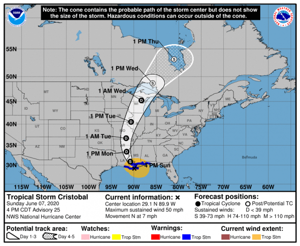
Cristobal makes landfall with 50 mph winds
Tropical Storm Cristobal made landfall around 5 p.m. Sunday in the Grand Isle-Barataria Bay area with 50 mph winds.
,
According to the most recent National Weather Service forecast, St. Mary Parish can expect 2 to 6 inches of rain, with heavier rain possible in areas beneath rain bands.
The storm slowed to 5 mph as it approached the Louisiana coast but is picking up speed again, meteorologist Donald Jones said in a Facebook update.
A slow or stationary storm would heighten the threat of heavy rain and flooding.
"It's not something we expect to stall in the area, although it has slowed a little bit," Jones said.
For now, the heaviest rain and wind are north and east of the landfall area, Jones said. But moving into Monday, some of the tougher weather will begin to wrap around to the south and east.
St. Mary and St. Martin can expect winds of 40-50 mph and a storm surge of 1-3 feet Monday, which could cause flooding around Cypremort Point, Burns Point, Franklin and Stephensville,Jones said in a Sunday morning update.
The Atchafalaya at Morgan City, once predicted to go to 9.5 feet, is now expected to reach 8 feet about 7 p.m. Monday. The river is forecast to begin rising about 7 a.m. Monday and be back below 6.5 feet overnight.
Winds of 12-18 mph with gusts of up to 28 mph were recorded at Harry P. Williams Airport in Patterson on Sunday. Less than half an inch of rain has been recorded at the airport.
Here's the 4 p.m. forecast discussion from the National Hurricane Center:
Tropical Storm Cristobal Discussion Number 25
NWS National Hurricane Center Miami FL AL032020
400 PM CDT Sun Jun 07 2020
At least two low-level vortices have been noted rotating
cyclonically within the broad inner-core circulation, with one swirl
located southeast of the advisory position approaching the
Mississippi Delta and the other swirl located inland to the
northwest of Grand Isle, Louisiana. The larger swirl in the
southeastern quadrant will likely become the dominant low-level
circulation center later tonight after that feature moves inland
and frictional convergence tightens up the broad inner-core wind
field a little bit. The initial intensity remains 45 kt based on
data from surface observations and NOAA Doppler radar velocity data
from Slidell and Mobile, along with a satellite intensity estimate
of T3.0/45 kt from TAFB.
The initial motion estimate is an uncertain 355/06 kt due to the
uncertainty in the center position. Some erratic motion will
still be possible for the next 6-12 hours due to the dumb-belling
motion of the multiple low-level circulations. Overall, however,
the models remain in excellent agreement on Cristobal turning
north-northwestward tonight and continuing that motion through
24 hours. By Monday night, a turn toward north is forecast,
followed by a faster motion toward the northeast on Tuesday and
Wednesday ahead of an approaching frontal system. The cyclone is
expected to slow down on days 3 and 4 during extratropical
transition. The new NHC forecast track is very similar to the
previous track forecast, and lies down the center of the the
tightly packed consensus models.
No significant intensification is expected before landfall occurs
late this afternoon or early evening primarily due to Cristobal's
broad wind field. However, intrusions of dry air could result in
wind gusts of 55-60 kt in some of the stronger squalls. After
landfall, only slow weakening is expected due to the cyclone's large
wind field. In the 60-96 hour period, some slight strengthening to
gale-force strength is forecast due to strong baroclinic forcing
during the extratropical transition, and a long southerly to
south-southwesterly wind fetch blowing across Lake Michigan. The
official intensity closely follows a blend of the GFS, UKMET, and
ECMWF global models.
Cristobal remains a broad and asymmetric storm. Therefore, one
should not focus on the exact forecast track, since the associated
winds, storm surge, and rainfall extend well away the center.
Key Messages:
1. There is a danger of life-threatening storm surge outside of the
Hurricane and Storm Damage Risk Reduction System from the Mouth of
the Mississippi River to Ocean Springs, Mississippi, and a Storm
Surge Warning is in effect for those areas. Life-threatening storm
surge remains possible in other portions of southern and
southeastern Louisiana where a Storm Surge Watch is in effect.
Residents in these locations should follow advice given by local
emergency officials.
2. Tropical-storm-force winds will continue to spread along the
northern Gulf coast from central Louisiana to the western Florida
Panhandle, including metropolitan New Orleans this evening, and a
Tropical Storm Warning is in effect for this area. These winds will
extend well east of Cristobals center.
3. Heavy rainfall will continue across north Florida into this
evening, diminishing overnight. Heavy rain will continue to push
inland across the central Gulf coast this afternoon and into the
Lower Mississippi Valley tonight. The Central Gulf Coast region
will be most prone to heavy rain issues after the passage of the
center of Cristobal from tonight through Monday. This heavy
rain will move up the Lower and Mid Mississippi Valley Monday into
Tuesday, then across the Upper Mississippi Valley and Northern
Plains Tuesday and Tuesday night. Flash flooding, and new and
renewed significant river flooding is possible, especially where
heavier rainfall occurs over portions of the Gulf Coast through the
Mississippi Valley.
FORECAST POSITIONS AND MAX WINDS
INIT 07/2100Z 29.1N 89.9W 45 KT 50 MPH
12H 08/0600Z 30.9N 90.8W 40 KT 45 MPH...INLAND
24H 08/1800Z 33.4N 91.6W 25 KT 30 MPH...INLAND
36H 09/0600Z 36.7N 91.7W 25 KT 30 MPH...INLAND
48H 09/1800Z 40.5N 90.6W 25 KT 30 MPH...INLAND
60H 10/0600Z 45.2N 88.3W 30 KT 35 MPH...INLAND
72H 10/1800Z 48.7N 85.8W 35 KT 40 MPH...POST-TROP/EXTRATROP
96H 11/1800Z 53.2N 81.0W 35 KT 40 MPH...POST-TROP/EXTRATROP
120H 12/1800Z...DISSIPATED
