
5 A.M. SUNDAY: Marco still headed for SE Louisiana landfall
FROM THE NATIONAL HURRICANE CENTER
TROPICAL STORM MARCO
Tropical Storm Marco Discussion Number 12
NWS National Hurricane Center Miami FL AL142020
400 AM CDT Sun Aug 23 2020
Thunderstorm bursts continue to fire near the center of Marco, then
weaken an hour or two later due to persistent shear. Overall, the
storm's appearance hasn't changed with nearly all of the deep
convection very near or northeast of the center. Although the
satellite presentation is somewhat lacking at the moment, the
earlier Air Force Reserve Hurricane Hunter mission found believable
SFMR values to 60 kt, so that value remains the initial wind speed.
The intensity forecast remains tricky with Marco due to its small
size and marginal environment. There are some models that briefly
relax the shear today, which will likely be enough of a change to
allow Marco to reach hurricane strength. Later on, while the
cyclone is near the coast of Louisiana, the shear is forecast to
increase, but it is unknown exactly how close to landfall this will
occur. Our best forecast at this time is that the strongest winds
will be confined to the coast, and that Marco will then weaken
faster than most hurricanes do over the swamps of Louisiana due to
the shear. No significant changes were made to the intensity
forecast, which is very close to the model consensus. The new
forecast necessitates the issuance of hurricane warnings for
portions of southeastern Louisiana.
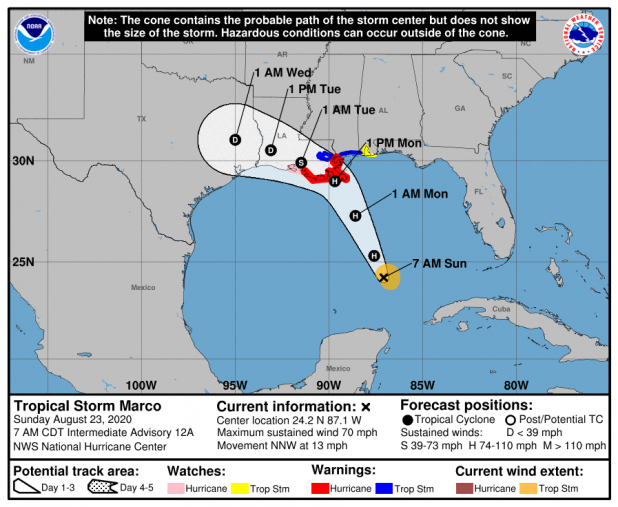
Marco continues moving north-northwestward or 335/11 kt. This
general track and speed is likely today, with a turn to the
northwest and decrease in forward speed expected as the storm
weakens late Monday. While the track forecast is essentially
unchanged from the previous one, there is still a fair bit of
spread in the model guidance, likely tied to the intensity
forecast. The stronger guidance is near or northeast of the new
model consensus, due to the upper-level flow, and the NHC forecast
leans in that direction, close to the previous official prediction.
Key Messages:
1. Hurricane conditions, life-threatening storm surge, and heavy
rainfall are expected from Marco along portions of the Gulf Coast
beginning on Monday, and Hurricane and Storm Surge Warnings have
been issued. Interests in these areas should follow any advice
given by local government officials.
2. Tropical Storm Laura could bring additional storm surge,
rainfall, and wind impacts to portions of the U.S. Gulf Coast by the
middle of next week. This could result in a prolonged period of
hazardous weather for areas that may also be affected by Marco.
Interests there should monitor the progress of Marco and Laura and
updates to the forecast during the next few days.
FORECAST POSITIONS AND MAX WINDS
INIT 23/0900Z 23.7N 87.0W 60 KT 70 MPH
12H 23/1800Z 25.3N 87.6W 65 KT 75 MPH
24H 24/0600Z 27.3N 88.6W 65 KT 75 MPH
36H 24/1800Z 29.0N 89.7W 65 KT 75 MPH
48H 25/0600Z 29.9N 91.5W 45 KT 50 MPH...INLAND
60H 25/1800Z 30.5N 93.1W 30 KT 35 MPH...INLAND
72H 26/0600Z 31.0N 95.0W 25 KT 30 MPH...INLAND
96H 27/0600Z...DISSIPATED
$$
Forecaster Blake
TROPICAL STORM LAURA
NWS National Hurricane Center Miami FL AL132020
500 AM EDT Sun Aug 23 2020
Laura has maintained an impressive convective pattern despite the
center being located over extreme south-central Dominican Republic.
Numerous cloud tops of -85C to -90C have been noted over the
Barahona peninsula, an indication that extremely heavy rainfall has
been occurring there. The center of Laura passed over or very near
Santo Domingo around 0430Z based on a noticeable wind shift that
was measured at the international airport. Laura's outflow pattern
has also continue to improve in all quadrants. The initial intensity
of 40 kt is based on earlier scatterometer and aircraft data, along
with surface observations along the north coast of the Dominican
Republic.
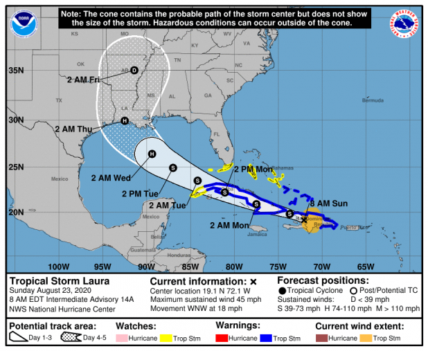
Laura has continued to move west-northwestward and the initial
motion estimate is now 285/16 kt. There has been a significant
westward shift in the latest NHC model guidance, which appears to be
due to most of the global models taking the center of Laura farther
south over central or southern Hispaniola rather than emerging it
off the north coast of Haiti like the GFS is and has been
forecasting. Given that the most intense convection has persisted
along the southern coast of Hispaniola, that is where the most
likely area that a low-level and/or mid-level circulation is most
probable to develop or persist. As a result, the new NHC track
forecast favors a more southerly and westerly track solution
similar to the preponderance of the track guidance. However, the
new forecast track has not been shifted as far to the left as the
consensus models in the event that the models shift back to the
north. However, the latter scenario is appearing less likely based
observed satellite trends since the previous advisory.
Little if any significant change in strength is expected due to
Laura moving pretty much down the spine of Hispaniola and Cuba
during the the next 36 hours, with the strongest wind likely
remaining over water in the northeast quadrant where the pressure
gradient will be the tightest between the cyclone and the Bermuda
High. By 48 hours and continuing until landfall, Laura is forecast
to remain in a low shear and very favorable upper-level outflow
environment while passing of extremely warm SSTs near 31C. This
should allow for significant strengthening to occur once the cyclone
regains a decent inner core after exiting Cuba. The new NHC
intensity forecast is a blend of the intensity forecasts by the GFS
and ECMWF global models and the corrected consensus models HCCA and
FSSE.
Key Messages:
1. Tropical storm conditions are expected across portions of the
Dominican Republic and Haiti, the Turks and Caicos, the
southeastern Bahamas, and Cuba through Monday. Heavy rainfall is
likely across these areas and could cause mudslides and flash and
urban flooding.
2. Tropical storm conditions are possible the central Bahamas and
Andros Island tonight and Monday, and in the Florida Keys on
Monday.
3. The details of the long-range track and intensity forecasts
remain uncertain since Laura is forecast to move near or over
portions of the Greater Antilles through Monday. However, Laura is
forecast to strengthen over the Gulf of Mexico and could bring storm
surge, rainfall, and wind impacts to portions of the U.S. Gulf Coast
by the middle of next week. This could result in a prolonged period
of hazardous weather for areas that are likely to be affected by
Tropical Storm Marco earlier in the week. Interests there should
monitor the progress of Laura and Marco and updates to the forecast
during the next few days.
FORECAST POSITIONS AND MAX WINDS
INIT 23/0900Z 18.8N 70.9W 40 KT 45 MPH
12H 23/1800Z 19.8N 73.7W 40 KT 45 MPH...OVER WATER
24H 24/0600Z 20.9N 77.5W 40 KT 45 MPH...INLAND
36H 24/1800Z 22.2N 81.1W 40 KT 45 MPH...INLAND
48H 25/0600Z 23.5N 84.2W 45 KT 50 MPH...OVER WATER
60H 25/1800Z 24.9N 87.0W 60 KT 70 MPH
72H 26/0600Z 26.4N 89.4W 75 KT 85 MPH
96H 27/0600Z 29.9N 92.5W 85 KT 100 MPH
120H 28/0600Z 35.0N 91.4W 30 KT 35 MPH...INLAND
$$
Forecaster Stewart
