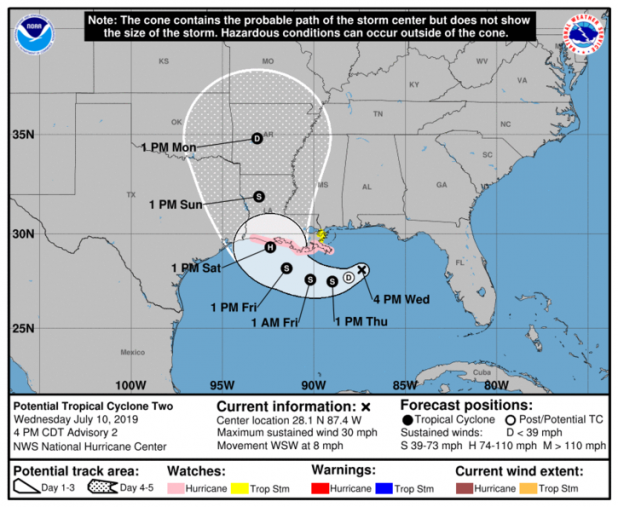
4 p.m. Potential Tropical Storm 2 update
BULLETIN
Potential Tropical Cyclone Two Advisory Number 2
NWS National Hurricane Center Miami FL AL022019
400 PM CDT Wed Jul 10 2019
...HURRICANE WATCH ISSUED FOR PORTIONS OF THE SOUTHERN COAST OF
LOUISIANA...
...HEAVY RAINS EXPECTED TO CONTINUE ACROSS THE CENTRAL GULF COAST...
SUMMARY OF 400 PM CDT...2100 UTC...INFORMATION
----------------------------------------------
LOCATION...28.1N 87.4W
ABOUT 125 MI...200 KM ESE OF THE MOUTH OF THE MISSISSIPPI RIVER
ABOUT 255 MI...410 KM ESE OF MORGAN CITY LOUISIANA
MAXIMUM SUSTAINED WINDS...30 MPH...45 KM/H
PRESENT MOVEMENT...WSW OR 245 DEGREES AT 8 MPH...13 KM/H
MINIMUM CENTRAL PRESSURE...1011 MB...29.86 INCHES
WATCHES AND WARNINGS
--------------------
CHANGES WITH THIS ADVISORY...
The Storm Surge Watch has been extended westward to Intracoastal
City Louisiana.
A Hurricane Watch has been issued from the Mouth of the Mississippi
River westward to Cameron Louisiana.
A Tropical Storm Watch has been issued from north of the Mouth of
the Mississippi River to the Mouth of the Pearl River.
DISCUSSION AND OUTLOOK
----------------------
At 400 PM CDT (2100 UTC), the broad disturbance was centered near
latitude 28.1 North, longitude 87.4 West. The system is moving
toward the west-southwest near 8 mph (13 km/h). A motion toward the
west-southwest or southwest is expected through Thursday morning,
followed by a turn toward the west late Thursday and a turn toward
the west-northwest on Friday. By early Saturday, a northwestward
motion is expected. On the forecast track, the system is expected
to approach the central U.S. Gulf Coast this weekend.
Reports from an Air Force Reserve reconnaissance aircraft indicate
that maximum sustained winds are near 30 mph (45 km/h) with higher
gusts. Strengthening is forecast during the next 72 hours, and the
disturbance is forecast to become a tropical depression Thursday
morning, a tropical storm Thursday night, and a hurricane on Friday.
Shower and thunderstorm activity has gradually been increasing in
coverage and organization, and the low is likely to become a
tropical depression or a tropical storm in the next day or so.
*Formation chance through 48 hours...high...near 100 percent
*Formation chance through 5 days...high...near 100 percent
The estimated minimum central pressure based on data from the
aircraft and surface observations is 1011 mb (29.86 inches).
NEXT ADVISORY
-------------
Next intermediate advisory at 700 PM CDT.
Next complete advisory at 1000 PM CDT.
$$
Forecaster Stewart
