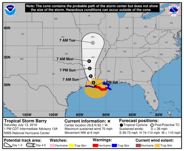
1 p.m. update: Barry inches its way to shore near Intracoastal City
BULLETIN
Tropical Storm Barry Intermediate Advisory Number 13A
NWS National Hurricane Center Miami FL AL022019
100 PM CDT Sat Jul 13 2019
...BARRY MAKES LANDFALL NEAR INTRACOASTAL CITY LOUISIANA AND WEAKENS
TO A TROPICAL STORM...
...DANGEROUS STORM SURGE, HEAVY RAINS, AND WIND CONDITIONS
CONTINUING ACROSS THE NORTH-CENTRAL GULF COAST...
SUMMARY OF 100 PM CDT...1800 UTC...INFORMATION
----------------------------------------------
LOCATION...29.8N 92.1W
ABOUT 5 MI...10 KM NE OF INTRACOASTAL CITY LOUISIANA
ABOUT 30 MI...50 KM SSW OF LAFAYETTE LOUISIANA
MAXIMUM SUSTAINED WINDS...70 MPH...115 KM/H
PRESENT MOVEMENT...NW OR 315 DEGREES AT 6 MPH...9 KM/H
MINIMUM CENTRAL PRESSURE...996 MB...29.41 INCHES
WATCHES AND WARNINGS
--------------------
CHANGES WITH THIS ADVISORY...
The Hurricane Watch has been discontinued for the Louisiana coast
west of Intracoastal City.
The Hurricane Warning for the Louisiana coast will likely be
discontinued later this afternoon as Barry moves farther inland.
SUMMARY OF WATCHES AND WARNINGS IN EFFECT...
A Hurricane Warning is in effect for...
* Intracoastal City to Grand Isle
A Tropical Storm Warning is in effect for...
* Mouth of the Pearl River to Grand Isle
* Lake Pontchartrain and Lake Maurepas including metropolitan New
Orleans
* Intracoastal City to Sabine Pass
A Storm Surge Warning is in effect for...
* Intracoastal City to Biloxi
* Lake Pontchartrain
A Storm Surge Watch is in effect for...
* Biloxi to the Mississippi/Alabama border
A Hurricane Warning means that hurricane conditions are expected
somewhere within the warning area.
A Tropical Storm Warning means that tropical storm conditions are
expected somewhere within the warning area within 36 hours.
A Storm Surge Warning means there is a danger of life-threatening
inundation from rising water moving inland from the coastline
during the next 36 hours in the indicated locations. For a
depiction of areas at risk please see the National Weather
Service Storm Surge Watch/Warning Graphic available at
hurricanes.gov. This is a life-threatening situation. Persons
located within these areas should take all necessary actions to
protect life and property from rising water and the potential for
other dangerous conditions. Promptly follow evacuation and other
instructions from local officials.
A Storm Surge Watch means there is a possibility of life-
threatening inundation from rising water moving inland from the
coastline in the indicated locations during the next 48 hours.
For storm information specific to your area, including possible
inland watches and warnings, please monitor products issued by your
local National Weather Service forecast office.
DISCUSSION AND OUTLOOK
----------------------
At 100 PM CDT (1800 UTC), the center of Tropical Storm Barry was
located near latitude 29.8 North, longitude 92.1 West. Barry is
moving toward the northwest near 6 mph (9 km/h), and a turn toward
the north-northwest is expected tonight, followed by a turn toward
the north on Sunday. On the forecast track, the center of Barry
will move through southern Louisiana this afternoon, into central
Louisiana tonight, and into northern Louisiana on Sunday.
Maximum sustained winds are now near 70 mph (115 km/h) with higher
gusts, and these winds are located over water to the southeast of
the center. Weakening is expected as Barry moves farther inland,
and it is forecast to weaken to a tropical depression on Sunday.
Tropical-storm-force winds extend outward up to 175 miles (280 km)
from the center. The National Ocean Service station at Eugene
Island, Louisiana recently reported sustained winds of 61 mph and a
wind gust of 72 mph.
The estimated minimum central pressure is 996 mb (29.41 inches).
HAZARDS AFFECTING LAND
----------------------
Key Messages for Barry can be found in the Tropical Cyclone
Discussion under AWIPS header MIATCDAT2 and WMO header WTNT42 KNHC.
STORM SURGE: The combination of a dangerous storm surge and the
tide will cause normally dry areas near the coast to be flooded by
rising waters moving inland from the shoreline. The water could
reach the following heights above ground somewhere in the indicated
areas if the peak surge occurs at the time of high tide...
Intracoastal City to Shell Beach...3 to 6 ft
Shell Beach to Biloxi MS...3 to 5 ft
Lake Pontchartrain...3 to 5 ft
Biloxi MS to the Mississippi/Alabama border...2 to 4 ft
Lake Maurepas...1 to 3 ft
Surge-related flooding depends on the relative timing of the surge
and the tidal cycle, and can vary greatly over short distances. For
information specific to your area, please see products issued by
your local National Weather Service forecast office.
RAINFALL: Barry is expected to produce total rain accumulations of
10 to 20 inches over south-central and southeast Louisiana and
southwest Mississippi, with isolated maximum amounts of 25 inches.
Across the remainder of the Lower Mississippi Valley and western
portions of the Tennessee Valley, total rain accumulations of 4 to 8
inches are expected, with isolated maximum amounts of 12 inches.
This rainfall is expected to lead to dangerous, life threatening
flooding.
WIND: Tropical storm conditions are occurring across the Hurricane
and Tropical Storm Warning areas to the east of the center. Wind
gusts to tropical-storm force in squalls are possible along portions
of the coasts of Mississippi, Alabama, and the western Florida
Panhandle through tonight.
TORNADOES: A few tornadoes are possible through tonight across
the southeast Louisiana, southern Mississippi, and southern Alabama.
