UPDATED AFTER PRESS CONFERENCE: Tri-City area watches one more tropical system approach
For the third time in three weeks, a tropical system likely to become a hurricane is stalking the Louisiana coast. And for the the third time, the storm's projected track is close enough to St. Mary Parish to bear watching.
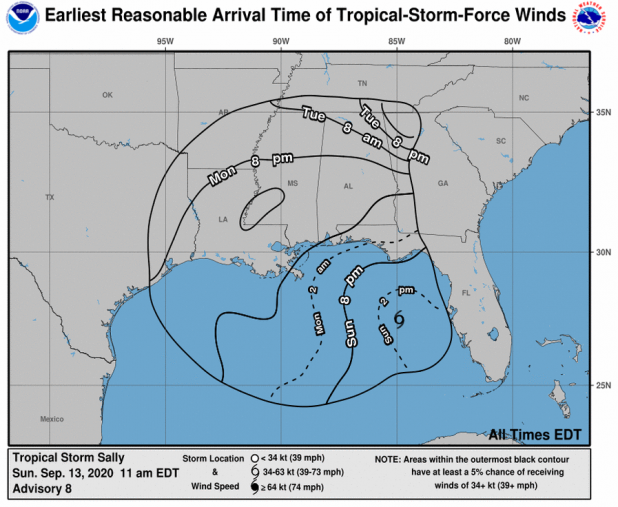
Morgan City is on the western edge of a hurricane warning as Tropical Storm Sally nears, and a tropical storm warning stretches from Intracoastal City to just west of Morgan City, according to the 1 p.m. update from the National Hurricane Center. Sally is expected to come ashore late Monday or early Tuesday as Category 2 hurricane with sustained winds of 100 mph and gusts to 120 mph at the coast.
Gov. John Bel Edwards, who declared an emergency Saturday, was set to give an update on the storm at 2 p.m. Sunday, and it will be streamed here.
At 1 p.m. Sunday, Sally packed winds of 60 mph and was expected to intensify. Tropical storm-force winds extend outward 90 miles from the storm's center. The projected track takes it near the tip of Plaquemines Parish about 8 p.m. Monday and near the mouth of the Mississippi about 8 a.m. Tuesday. Meteorologists warn that the three- and five-day "cones" are subject to rapid change.
One such change jogged the track westward early Sunday, leading to the advisories in the Morgan City area.
St. Mary Parish public schools will be open Monday. A Facebook post from the system said the effects of the storm aren't expected to be felt here until Monday evening.
A post from the St. Mary Parish Office of Emergency Preparedness and Homeland Security said the office is monitoring Tropical Storm Sally.
The storm is expected to bring 1-3 inches of rain to St. Mary with gusts of 30-40 mph.
"Storm surge should not be a problem for this system; wind direction should be northerly," the post said.
The latest from the National Weather Service says the Atchafalaya River at Morgan City is at 3.5 feet, or 2.5 feet below flood stage, and is expected to stay at about that level through at least Friday.
In Berwick, Mayor Duval Arthur said a town employee was on duty to make preparations Sunday. He doesn't think flood gate closures will be required.
State offices in 17 southeast Louisiana parishes will be closed Monday. Assumption and St. Martin are on that list, but St. Mary isn't.
At an Edwards press conference Sunday afternoon, National Weather Service meteorologist Benjamin School noted that south Louisiana has missed the worst of recent storms including Cristobal, Marco and Barry.
"I don't believe we'll be that lucky this time," Schott said.
The threats in southeast Louisiana:
--Sally could slow to 3-5 mph as it runs into high pressure near the coast, Schott said. An average of 6-12 inches of rain could fall on areas of southeast Louisiana, possibly 15 inches in the New Orleans area. Some isolated areas caught under slow-moving rain bands may measure the rainfall in feet, Schott said.
"It's all going to be about the speed as it goes into Louisiana," Schott said.
--From extreme southeast Louisiana into Mississippi, the storm surge could reach 9 feet, Schott said.
--Hurricane-force winds of at least 74 mph may be felt 40-60 miles from the storm's center.
About 12,000 evacuees from Laura's strike in southwest Louisiana are in hotels in the New Orleans area, Edwards noted, and find themselves in the path of a second hurricane. Preparations are underway to make sure the evacuees have food, Edwards said.
National Guard troops, some of whom have been activated since the beginning of the COVID-19 pandemic, are standing by for hurricane relief, the governor said.
Edwards said he spoke with President Donald Trump earlier Sunday to ask for a pre-landfall declaration that would make federal resources available to Louisiana. The governor also asked Trump for 100% federal reimbursement for some expenses related to Hurricane Laura recovery, including debris removal. There was no immediate word about the president's decision.
Cleco says it is shifting one-third of the company's contractor line mechanics and vegetation specialists, or approximately 500 people, from its Hurricane Laura restoration efforts to Tropical Storm Sally. The company expects this number to fluctuate as the track of the storm and its impact become better known.
“As we are wrapping up power restoration efforts and system repairs across much of our service territory, we are able to shift resources in preparation of Tropical Storm Sally,” said James Lass, director of distribution operations and emergency management. “This redirect of resources will not impact our continued restoration efforts and system repairs for Hurricane Laura.”
Cleco has restored power to 99% of customers impacted by Hurricane Laura.
During the week of Aug. 23, a system named Marco appeared headed for landfall somewhere near St. Mary, but it fizzled. it was followed by Laura, which missed the central and southeast Louisiana coastlines but caused widespread devastation in Cameron, Calcasieu and parishes to the north Aug. 27.
