Still reeling from Dorian, Bahamas faces tropical storm; update on system in eastern Gulf
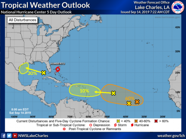
National Weather Service update: A large area of showers and thunderstorms over the eastern Gulf of Mexico is primarily associated with a upper-level low pressure area. Only slow development of this system is likely during the next couple of days. However, conditions could become more conducive for development early next week as the system moves over the western Gulf of Mexico.
* Formation chance through 48 hours...low...near 10 percent.
* Formation chance through 5 days...low...30 percent.
FREEPORT, Bahamas (AP) — Officials temporarily suspended aid efforts and closed airports in the Bahamas on Saturday as Tropical Storm Humberto threatened to lash the archipelago's northwest region that was already hit by Hurricane Dorian two weeks ago.
Humberto's arrival coincides with a weekend visit to the Bahamas by U.N. Secretary-General Antonio Guterres aimed at supporting humanitarian aid efforts in the wake of Dorian, which reached the islands as a massive Category-5 storm and left thousands of people in need of food, water and shelter.
Threatening to exacerbate the problem, winds and rains from Humberto could be expected in Grand Bahama and the nearby Abaco islands, said chief meteorologist Shavonne Moxey-Bonamy.
"I know it might be a bit of a disheartening situation since we just got out of Dorian," she said.
At 8 a.m. EDT, Humberto was located 30 miles (45 kilometers) east-northeast of Great Abaco island, according to the U.S. National Hurricane Center. It had maximum sustained winds of 40 mph (65 kph) and was moving northwest at 7 mph (11 kph). There was a tropical storm warning in effect for the northwest Bahamas, except for Andros Island, and 2 to 4 inches of rain was expected, with isolated amounts of 6 inches.
"Rains are the biggest issue right now," parliament member Iram Lewis said by telephone. "People are still reeling from the first storm."
Humberto is forecast to become a hurricane by Sunday but is expected to stay offshore of Florida's eastern coast as it moves toward open waters. Portions of the coasts of Florida and Georgia will see 1 to 2 inches of rain.
The hurricane center said most of the heavy squalls were occurring north and east of the center of the storm, which was passing just east of Abaco. However, government officials in the Bahamas took no chances and urged people in damaged homes to seek shelter as they announced that aid efforts would be temporarily affected.
"The weather system will slow down logistics," said Carl Smith, spokesman for the National Emergency Management Agency.
The distribution of meals in Grand Bahama was reduced ahead of the storm, and a spokesman for the United Nations World Food Program said all flights into its logistics hub in Marsh Harbor in Abaco were suspended.
Dave McGregor, president and COO of the Grand Bahama Power Company, said crews would resume restoring power as soon as possible.
"We are back in storm preparation mode again, unfortunately," he said.
Guterres said he hoped the weather will allow him to visit the islands and see the impact for himself.
"In some areas, more than three-quarters of all buildings have been destroyed. Hospitals are either in ruins, or overwhelmed. Schools turned into rubble," the U.N. secretary-general said in a prepared statement ahead of the visit.
He said thousands of people continue to need food, water and shelter, and U.N. humanitarian agencies are on the ground to help them.
"Our hearts go out to all the people of the Bahamas and the United Nations is right by their side," he said.
