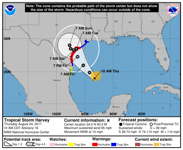
NWS Thursday morning statement on Tropical Storm Harvey
Vernon-Rapides-Avoyelles-Beauregard-Allen-Evangeline-St. Landry-
Calcasieu-Jefferson Davis-Acadia-Lafayette-Upper St. Martin-
Vermilion-Iberia-St. Mary-Lower St. Martin-West Cameron-
East Cameron-Tyler-Hardin-Jefferson-Orange-Northern Jasper-
Northern Newton-Southern Jasper-Southern Newton-
430 AM CDT Thu Aug 24 2017
This Hazardous Weather Outlook is for portions of central
Louisiana, south central Louisiana, southwest Louisiana, west
central Louisiana, and southeast Texas.
.DAY ONE...Today and Tonight
A cool front is moving through southern Louisiana this morning and
looks to move into the gulf. Scattered showers and thunderstorms
on tap for today and tonight. Storms today will produce cloud to
ground lightning and gusty winds.
.DAYS TWO THROUGH SEVEN...Friday through Wednesday
Tropical Storm Harvey is expected to move to the northwest and
into the middle Texas coast by Saturday morning. Harvey is
expected to strengthen into a hurricane on Friday prior to
landfall. Looking for showers and thunderstorms over the weekend
and into next week as this will be a prolong event. An upper level
ridge will block Harvey from moving deeper into Texas. By Monday
Harvey will push the front to the northeast... this will allow
area coverage of storms to increase through the beginning of next
week. Rainfall totals at this time are expected to range from five
to eight inches.
